


la vaupaliere

dedejojo
User
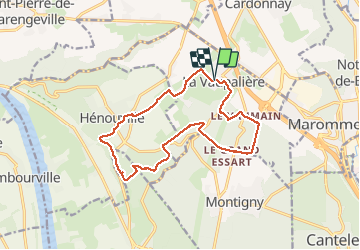

Length
13.8 km

Max alt
145 m

Uphill gradient
223 m
Km-Effort
16.8 km

Min alt
71 m

Downhill gradient
225 m
Boucle
Yes
Creation date :
2021-04-18 11:39:49.644
Updated on :
2021-04-18 14:59:13.243
3h18
Difficulty : Very easy

FREE GPS app for hiking
 SityTrail
IGN / Geographical institutes
SityTrail Plus
The world is yours!
About
Trail Walking of 13.8 km to be discovered at Normandy, Seine-Maritime, La Vaupalière. This trail is proposed by dedejojo.
Positioning
Country:
France
Region :
Normandy
Department/Province :
Seine-Maritime
Municipality :
La Vaupalière
Location:
Unknown
Start:(Dec)
Start:(UTM)
354632 ; 5483467 (31U) N.
Comments